
Home page
A protest campaign over poor walking and cycling safety
- Children are being harmed on Merseyside's roads: Who's responsible?
- Why a protest campaign is needed
- Civil disobedience and road safety: Q and A
Effective road safety planning: what should be happening
What the vision should be- A road safety vision
- Walking safely is a basic human right
- Declaration of every child's right to safe and healthy streets
- Decision making in a democracy: 7 Principles of Public Life
- Effective road safety planning
- What constitutes proper consultation
- Public bodies should avoid 'The patronising disposition of unaccountable power': the Hillsborough Report by the Right Reverend James Jones
- Merseyside road casualties - summary
- Merseyside road casualty maps
- Merseyside pedestrian casualties: the worst in Great Britain
- Merseyside child pedestrian casualties: the third worst in Great Britain
- Liverpool pedestrian casualties: the worst metropolitan borough
- Merseyside cyclist casualties: bottom third position
- Merseyside child cyclist casualties: the fifth worst in Great Britain
- Cyclist casualties: Liverpool is the worst metropolitan borough
- Motorcyclist casualties: Merseyside is the worst metropolitan area
- Motorcyclist casualties: The Wirral is the second worst metropolitan borough
- Car occupant casualties in Merseyside
- Total (all modes) road casualties: Merseyside is the worst metropolitan area
- Total (all modes) road casualties: Liverpool is the third worst metropolitan borough
- Pavement parking: Questions and answers
- Childhood obesity levels in Merseyside
- Deaths from air pollution in Merseyside
Options that should be considered
- Best practice options: policy documents
- Best practice options: Safe System approach to road safety
- Best practice options: 20mph speed limits
- Best practice options: 20mph speed limits: Pedestrian fatality risk and impact speed
- Best practice options: 20mph speed limits: Recommendations
- Best practice options: cycling infrastructure
- Best practice options: actions by police forces against illegal pavement parking
- Best practice options: regulated (permitted) pavement parking
Merseyside road safety failures
- Why children are suffering so much harm from the danger on Merseyside's roads
- Liverpool City Region Road Safety Strategy 2017-2020
- Liverpool City Region Local Journeys Strategy
- Liverpool Council never completed its Inquiry into poor road casualty figures
- Liverpool Council: Appalling cycling infrastructure
- Wirral Council road safety malpractice
- Wirral Council's failing road safety scrutiny committee
- Merseyside Police: failure of public engagement: a case history
- Improvements needed from Merseyside Police
- Why are road safety volunteers having so little effect?
Merseyside / national road safety failures
- How changes in the Highway Code caused the pavement parking confusion
- Why the Living Streets / Guide Dogs pavement parking campaign is inept and dangerous
- Flawed DfT "Consultation" on pavement parking
- Two child pedestrian deaths from pavement parking
- The 2018 Atkins/AECOM/Mayer 20mph Research Study was seriously flawed
Merseyside road safety concerns
So-Mo project on pedestrian casualties- So-Mo project outline
- So-mo project to reduce pedestrians killed or seriously injured on Liverpool's roads: Concerns and questions
- So-Mo meeting on 16th March 2018: Response by Liverpool Pedestrians Association
- So-Mo reports of May 2018: Response by Liverpool Pedestrians Association
Merseyside road safety improvements
- Merseyside Police and Crime Plan 2017 - 2021
- Merseyside Police leading the way in tackling pavement parking
Taking action on poor road safety
Current campaigns
- Voluntary groups
- Vision Zero Merseyside 2013
- Letter to Jane Kennedy and Steve Rotheram re LCR road safety strategy
- Letter to Jane Kennedy and Steve Rotheram: Replies from Jane Kennedy, Steve Rotheram and Sean Traynor
- Meeting notes: Merseyside Road Safety Partnership with Liverpool Pedestrians Association, 27 March 2018
Newsletters
- Newsletters: contents
- Newsletter - August 2018
- Newsletter - 16 December 2017
- Newsletter - 23 November 2017
- Newsletter - 2 November 2017
News
- PCC Scrutiny Group meeting 5 December 2017 - Provisional
- Highlights of the 9th 20mph conference in Birmingham, 8 March 2017
- Merseyside Police Performance and Scrutiny Group meeting of 2 March 2017
About
Contact
Merseyside road casualty maps
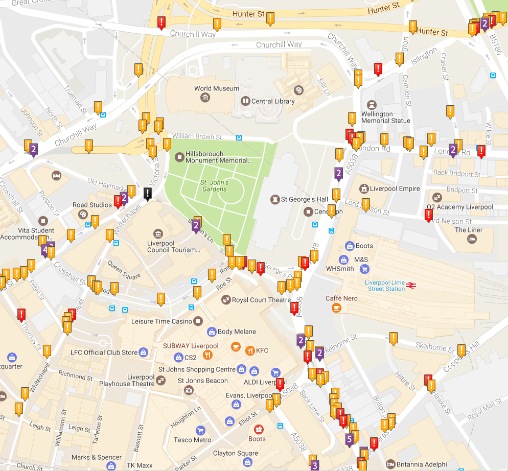
Crashmap
The locations of road casualties in Merseyside (and elsewhere) can be viewed onhttps://www.crashmap.co.uk/.
Enter any postcode, and you can see the location of collisions for all road users and all casualty types for the last 10 years - and you can also select any combination of year, road user type and casualty type.
GridReferenceFinder
If you have the grid references of collision sites, they can be displayed on a map using http://gridreferencefinder.com.Last updated: 7 Feb 2019
|
| wacm.org.uk |